Street Space Data (Select City Tab)
Guelph
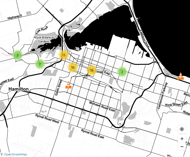
Hamilton
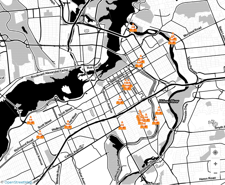
Ottawa
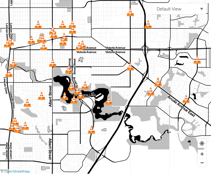
Regina
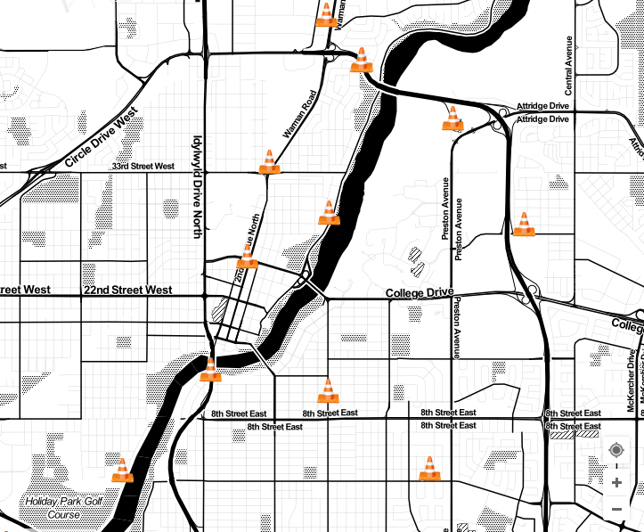
Saskatoon
| City | Issue Category | Location Coordinates | Location Description | Issue |
|---|---|---|---|---|
| Guelph | Cycling | 43.550310681832,-80.277585089207 | All along Edinburgh from Woodlawn on south | Bike lanes that are separated by a good barrier, ideally. |
| Guelph | Cycling | 43.538759719911,-80.206831097603 | Stone Road and Victoria intersection. | Bike path along Victoria ends. Cars frequently cut into the bike lane to turn right with no awareness of anyone in the bike lane. There is enough space and roadway turn right without going into the bike lane, but drivers don't. Please separate this section of the bike lane from cars entirely (a barrier of some sort is in place). Many near-misses or sudden braking. |
| Guelph | Cycling | 43.530566942622,-80.237928271381 | Residential 'signed routes' | Broader education about the existence of the signed routes, and clearer signage on the routes themselves. Include 'turn' signs AND 'go straight' signs to reduce ambiguity. Place chevrons on roads (like Bristol street) along all residential signed routes. |
| Guelph | Cycling | 43.51228992771,-80.241678357124 | Stone Road and Hanlon | Crossing Hanlon is terrible. Long wait, pedestrian crossing only, no space for a cyclist, I go on the sidewalk here. Cars are eager to turn right on green. Is it possible to put an advance-bicycle push button and a bike lane on this part of Stone ? |
| Guelph | Cycling | 43.53011591054,-80.24812605232 | Edinburgh Road | Edinburgh needs bike lanes! This important north-south connector has four driving lanes, wide boulevards in part, but no safe place to bike. |
| Guelph | Cycling | 43.559402655821,-80.270134680031 | Downtown trail | Extending this trail and connecting it to the Kissing Bridge trail. It would be amazing to be able to ride a bike (away from cars) all the way to Goderich. |
| Guelph | Cycling | 43.546432957678,-80.232550621731 | York rd. between Wyndham and Victoria | Fix bike lanes which exist, and extend them all the way to Victoria. That would be great. |
| Guelph | Cycling | 43.5676018798,-80.237673819065 | Grange Road | Great bicycle street. Just wondering if there is a bike route sign here? I don't feel a need for bike lane here. |
| Guelph | Cycling | 43.549336090042,-80.221250653267 | Victoria Road north of College Avenue | Great progress with the bike lane south of the bridge, but north of the bridge, the bikelane suddenly ends. There are no safe alternative routes here either. I turn left onto York Road to get as fast as possible to Stevenson, but that is 5 minutes of scary, on-road manoeuvering. |
| Guelph | Cycling | 43.548566275539,-80.250509865582 | Missed opportunity for cycle-centric crossing | Natural curb cuts to guide cyclists would help the crossing here. Right now they are lopsided, require cyclists to awkwardly weave around the rail tracks, and dodge cars. Due to the hill to get to the intersection people will not make that choice to up and back down, so acknowledging this with visual changes would make trail users feel supported. |
| Guelph | Cycling | 43.545489409424,-80.288199931383 | Silvercreek between Speedvale and Woodlawn | No bike lane at all and also no space for riders, many employees for Linamar and other industries ride their bikes along here on a daily basis. This area is well-traveled by cyclists and also connects the Woodlwan multi-use path with the bike lane along Silvercreek. Important! |
| Guelph | Cycling | 43.55897239639,-80.266943273018 | Speedvale needs permanent room for bikes | No room for cycling on Speedvale between Woolwich and Edinburgh. |
| Guelph | Cycling | 43.539340431667,-80.263710021973 | Paisley | Paisley is an important arterial route between the west end and downtown and it provides access for students of GCVI and Paisley PS. West of the Hanlon Paisley is 4 lanes with - plenty of space for a cycle path. East of Hanlon the road narrows and with the arterial traffic it can be nerve wracking even for strong cyclists. Worst, between Dublin and Glasgow the road narrows (through the "canyon") making being passed by a bus or truck quite unpleasant. The intersections at the Hanlon, Silvercreek and Edinburgh are dangerous. Protected lanes and improved intersections would create a safe route along this underused (by cyclists) route. |
| Guelph | Cycling | 43.535140516391,-80.236833930103 | Gordon corridor | Protected bike lanes along entire Gordon St. corridor; particularly necessary on the Gordon St. Hill!! :) |
| Guelph | Cycling | 43.551482878132,-80.277591960771 | Edinburgh needs room for bikes | Reduce to 2 lanes. Add bike lanes. Or, create bike path on existing grass. |
| Guelph | Cycling | 43.553866771189,-80.261928320106 | Woodlawn Road | The "bike lane" is barely 1 m wide. Ideally, a cyclist should ride roughly 1 m away from the curb to allow them to move around obstacles by moving in towards the curb rather than in to traffic. Legally, cars needs to give cyclists 1 m room when passing. The tight lanes along Woodlawn make these two considerations difficult for everyone. |
| Guelph | Cycling | 43.573426693466,-80.263136029243 | Inverness crossing Woodlawn. | The crosswalk is only activated by pedestrian touch button or by a car. if neither is there, the cyclist has to wait for a long time or run a red. |
| Guelph | Cycling | 43.510090504297,-80.210151672363 | Edinburgh Road South | The section of Edinburgh between Kortright and Gordon does not have any bike lanes. It is a fairly wide two lane road, so there is lots of space to provide a bike lane (ideally protected). I have seen many people biking along the sidewalk here since they clearly don't feel safe on the street. Additionally, this would provide a continuation of the bike lanes on Edinburgh which currently end at Kortright. |
| Guelph | Cycling | 43.556074965919,-80.217639684852 | Victoria Rd | The stretch has no bike lane and barely has a shoulder. The road is in terrible condition, with many potholes and rough asphalt and hazards. Consider adding a proper bike lane. |
| Guelph | Cycling | 43.567656761392,-80.278730140999 | Travel to Ignatius by bike is unsafe. | There is a lack of bike lane/sidewalk connectivity on the West side of HWY 6, so going to Ignatius (for public garden, schools, meetings) means either crossing the highway twice, or walking the bike half a km |
| Guelph | Cycling | 43.536561261133,-80.249175131321 | Wellington Road from Dublin to the River Run Center | There is not direct, safe, protected bike route along Wellington to connect from the LCBO/Goodness me! plaza to The Ward and the Speedriver trail. arts can be done on the sidewalk, but that is not officially a multi-use trail. |
| Guelph | Cycling | 43.540377402594,-80.246141552925 | Woolwich between Waterloo and Wellington | There is now a great green bike path, but it is still very unsafe. Cars regularly do not obey or forget to watch out for bikes. This stretch needs to be separated before another accident happens (particularly in and out of MacDonald's). |
| Guelph | Cycling | 43.521916650823,-80.229289233685 | Stone Road: lack of protected infrastructure on a busy route | There should be protected bike lanes on Stone Road. It is a major route for university students heading to the University of Guelph. |
| Guelph | Cycling | 43.546203552407,-80.270200878404 | No safe way to cross Edinburgh | This intersection is nearly impossible to safely navigate on a bicycle. If headed NB on Edinburgh and want to turn left onto Willow, you have to merge with cars going 60+ km/h and cross a busy lane of traffic to claim the turn lane, which is also a through lane. If you're not comfortable doing that, you can push a beg button to cross Edinburgh, then wait to cross the slip lane ("pedestrians yield to cars" sign, which most motorists aren't aware of resulting in confusing standoffs), then push another beg button to cross Willow. This is a high-traffic area, and a major pedestrian and cyclist corridor between a dense residential neighbourhood and a school. This intersection should be totally redesigned for pedestrian and active transport safety. The slip lanes are particularly dangerous and could be either eliminated, or reduced in width and designated for bicycle traffic alone. Another improvement could include an "advance green" for cyclists alone, triggered by a button mounted at the bike lane headed NB on Edinburgh. |
| Guelph | Cycling | 43.539099819421,-80.245688175783 | One way for cars, but make two-way for bikes? | This is a logical connection to the parks and shopping centre across Wellington, forcing cyclists to go around when there is a useful crosswalk at the end of this one way street (bristol) is illogical and though possible causes confusion |
| Guelph | Cycling | 43.529360536673,-80.236374540254 | Improved signage to alert drivers of neighbourhood bike route | This is a main access route for many trying to avoid using Gordon St, having more dedicated signage to alert both cyclists and drivers to bikes crossing at College could be a helpful support |
| Guelph | Cycling | 43.557007981628,-80.240962207317 | Painted bike lanes on Stevenson Road | This road needs to add protected bike lanes! This road serves 5 different schools, yet it is dangerous to cycle to school due to lack of protected infrastructure. |
| Guelph | Cycling | 43.546964365319,-80.244051106274 | Missed opportunity for cycle-centric crossing | To further support the other point made about this location, the two sections of the trail are not effectively connected. even natural curb cuts to guide cyclists and give drivers an expectation of where cyclists will be would help reduce danger here. right now it is a free for all, and/or requiring going up to the light and back down |
| Guelph | Cycling | 43.548173760441,-80.229211114347 | Narrow busy main street for bike lane as is | With the amount of heavy truck traffic and buses, and cars going to/from downtown, the bike lanes are not given priority. separated infrastructure here would be wonderful. |
| Guelph | Cycling|Pedestrian Zone|Walkability | 43.546977305677,-80.248783930547 | Douglas St | It would be great to have this as a pedestrian & cycle only street. |
| Guelph | Cycling|Walkability | 43.548641424787,-80.25063123554 | Trail crossing at Eramosa Rd | Difficult for bikes and pedestrians to cross here safely on the RRT. Add crosswalk? |
| Guelph | Cycling|Walkability | 43.540398141992,-80.253104388757 | Glasgow St. crossing | Don't let Dublin St. closure happen here! Future increase speed/frequency of transit rail is important, but so is maintaining the walk-ability/bike-ability of Guelph. Glasgow St. is part of a long pedestrian and cyclist friendly corridor located midway between Gordon/Norfolk/Woolwich and Edinburgh, which connects Bristol St. (near LCBO/Goodness Me plaza) through to Speedvale Ave and beyond. Please think ahead an plan for future rail requirements and how they may affect active transportation in this area. |
| Guelph | Cycling|Walkability | 43.539402650435,-80.255089223429 | Yorkshire St. crossing | Don't let Dublin St. closure happen here! Future increase speed/frequency of transit rail is important, but so is maintaining the walk-ability/bike-ability of Guelph. Yorkshire St. is part of an important north-south pedestrian and cyclist friendly corridor, and is currently designated as a 'signed route' through a residential neighbourhood. Please think ahead an plan for future rail requirements and how they may affect active transportation in this area. |
| Guelph | Cycling|Walkability | 43.529708386602,-80.247376626357 | Turn sidewalks into Multi Use paths | Edinburgh doesn't have enough space for bike lanes to be squeezed in next to the traffic, with bit of widening and a painted centre lane on the sidewalks they could be turned into shared recreational pathways and be positive connectors rather than negatively "no bikes on sidewalks' |
| Guelph | Cycling|Walkability | 43.541416948363,-80.251226842447 | Dublin St. crossing | Get creative and find way to re-open crossing for Pedestrians and Cyclists. Possibly a ramp with switch-backs on south side of crossing, parallel to Kent St, in order to meet new grade regulations. |
| Guelph | Cycling|Walkability | 43.55834527895,-80.261531732976 | Western end of Emma Street | Is this pedestrian/bicycle bridge ever going to be built? Badly needed. |
| Guelph | Cycling|Walkability | 43.539615230702,-80.279860273004 | Intersection Silvercreek at Willow | Left-turning lane has advance green, but you are stranded if you are a cyclist. It does not turn green. Please change to a timer or have a cyclist button or sensor or, have the pedestrian light turn green BEFORE the cars. |
| Guelph | Cycling|Walkability | 43.559288625716,-80.21095097065 | York Road | Remember to add a bike lane or multi-use path when redoing York Road East of Victoria. |
| Guelph | Cycling|Walkability | 43.547210596172,-80.243406503214,18 | Foot bridge at Elizabeth St intersection | Their is a disused foot bridge over the river here. Any possibility of opening it up to bike and foot traffic? |
| Guelph | Cycling|Walkability | 43.547058957453,-80.244038656365 | Dangerous crossing for Downtown Trail users | There is no designated crossing for trail users here, and during peak hours there are few/no breaks in motor vehicle traffic, particularly due to the slip lane under the bridge. Consider eliminating the slip lane from Wellington onto Macdonell, and adding a designated crossing for trail users. Could include signs requiring traffic on Macdonell to yield to trail users, and a raised grade for the trail where it crosses the road to visually and physically delineate the crossing. The rail crossing could happen on the South side of Macdonell so that road and track crossings can be kept close to perpendicular. |
| Guelph | Cycling|Walkability | 43.542731260922,-80.289866209205 | Speedvale Ave SW of the Hanlon | There is no sidewalk on this side of the road. However, the area sees a lot of activity by active transportation modes, as demonstrated by footprints and tire tracks through the mud/snow (depending on season). Consider adding a shared use lane here. There is a bus stop along this road but access can be sketchy, particularly in some seasons, and is absolutely not accessible for folks with mobility issues/disabilities. |
| Guelph | Cycling|Walkability | 43.545259676616,-80.252231173217 | Norfolk & Quebec/Paisley & Yarmouth | This is a really bad intersection for pedestrians and cyclists. It's massively overbuilt, with large unbroken spaces of asphalt to permit high vehicle volumes and fast turns. It doesn't feel safe, and it encourages risky driving. The corners should be tightened to slow turns and pedestrian refuges should be installed in the middle of the road. Green asphalt should be installed on the road to clearly mark the path cyclists take north through the intersection to continue on Norfolk or go to Yarmouth. I would like to see Danish-style two-part left-turn facilities for bikes. And bollards should be installed between Yarmouth and Norfolk to protect pedestrians standing on that small piece of sidewalk. |
| Guelph | Cycling|Walkability | 43.547583860272,-80.282878428698 | Speedvale stretch between Hanlon and Woolwich | This is one of a few roads that connect Silvercreek and East of there. I cannot ride on the road here - too narrow and busy. Ideal location for a multi-use path - wider, smoother sidewalk shared with cyclists. The current sidewalk is too old and narrow to pass a pedestrian safely. |
| Guelph | Cycling|Walkability | 43.558086115042,-80.268143713474 | Speedvale and Woowich | Turning left at the turn-left lane does not activate, except for cars. Improvement: either have the pedestrian lights turn white BEFORE the cars have a green light (advance pedestrian crossings), or make the left-turn lights bicycle-friendly (either by activating for cyclists or by turning green on a timer, instead of by car presence) |
| Guelph | Cycling|Walkability | 43.555484048498,-80.26044809827 | Give cyclists/pedestrians the right-of-way | Where the Downtown Trail crosses George St, John St, and others, stop signs should be eliminated for trail users. There is easily ten times more active transport traffic on the trail than vehicular traffic going into Armtec - those motorize road users should yield to trail users. The steel gates at all these road crossings also unnecessarily obstruct cyclists and pedestrians, and create dangerous pinch points. They are very difficult to navigate for strollers, bicycle trailers, and mobility scooters. If the intent is to prevent cars from driving down the Trail, a simple removable bollard would achieve this aim while vastly reducing the obstruction. |
| Guelph | Pedestrian Zone | 43.536696074676,-80.245985984802 | Gow Bridge | Closing the Gow bridge to car traffic would reduce conflicts between all other bridge users. Any time cars want to cross it forces other bridge users (pedestrians, bikers etc) into a very narrow space on one side of the bridge. |
| Guelph | Walkability | 43.542601645414,-80.249336846391 | Norfolk Street under the bridge | The sidewalks are narrow here and make distancing difficult between pedestrians and also between pedestrians and cyclists. |
| Guelph | Walkability | 43.540600349206,-80.242858361453 | Wellington Plaza Riverside Trail | There is a trail behind the Animal Vet Clinic that is only 3ft wide. I believe the city owns the property.The chain link fence that marks the back of the property could be moved 5 to 10 ft west to allow hikers, pedestrians to use the trail.This would have no impact on Animal Vet Clinic use of the property. This also contributes to safer bike travel in Guelph.Gets people off a busy Gordon/Wellington corner.It also connects trails. |
| Guelph | Cycling|Walkability | 43.559869139718,-80.265509784222 | Speedvale Rd. trail crossing | A safe passage under the Speedvale bridge needed to connect the trails along the Speed River north and south of Speedvale. |
Map:
| City | Issue Category | Location Coordinates | Location Description | Issue |
|---|---|---|---|---|
| Hamilton | Walkability | 43.25227505677,-79.890555739403 | Stanley Avenue | Allow parking on both sides of the street to slow traffic. |
| Hamilton | Cycling | 43.253244019883,-79.875806182645 | Cycle Lanes | Better separation barriers between cycle and traffic lanes. |
| Hamilton | Cycling | 43.253079922376,-79.89189666514 | Cycle Lanes | Better separation between cycle and traffic lanes. |
| Hamilton | Pedestrian Zone | 43.262036264713,-79.905763864517 | Parking lots in Westdale Village | Close to traffic for restaurant patios. |
| Hamilton | Pedestrian Zone | 43.251720240304,-79.869087159677 | Augusta | Close to traffic! |
| Hamilton | Pedestrian Zone|Walkability | 43.247898902295,-79.817567288919 | Ottawa Street (Near Cannon) | Create more pedestrian space on the roadway. |
| Hamilton | Cycling|Walkability | 43.251579581805,-79.894948840229 | Aberdeen Ave. | Dedicate one traffic lane for pedestrians and cyclists. |
| Hamilton | Pedestrian Zone | 43.26355002012,-79.865970611572 | James N (Cannon to Barton) | Make pedestrian only |
| Hamilton | Pedestrian Zone | 43.252626698392,-79.884177446365 | HAAA at Kent St. | Make this a pedestrian area. |
| Hamilton | Pedestrian Zone | 43.254939668237,-79.885877788111 | Locke (Canada to Herkimer) | More room for pedestrians! |
| Hamilton | Walkability | 43.25099154762,-79.887512728583 | Locke Street | More space in front of Melrose United Church |
| Hamilton | Walkability | 43.254420039081,-79.865611195564 | Main & Catharine, NE corner | Reduce car lanes on Main and widen sidewalks (blind corner not up to accessibility standards) |
| Hamilton | Walkability | 43.259377823806,-79.887229085143 | Main Street | Reduce one lane on each side to give more width on sidewalks for pedestrians. |
| Hamilton | Walkability | 43.261362387295,-79.885319352325 | King Street | Reduce one lane on each side to give more width on sidewalks to pedestrians. |
| Hamilton | Walkability | 43.240935479826,-79.820399712771 | Ottawa/Maple | Road diet for Ottawa and controlled pedestrian crossing. |
| Hamilton | Cycling | 43.241906251668,-79.738005214967 | North Service Road - Grays Road to Centennial Parkway | With the closure of Centennial Park, there are no safe bicycle connections through this stretch of North Service Road. |
| Hamilton | Walkability | 43.257486959047,-79.862987995148 | Crossing at Mary & Wilson | A pedestrian crossing or full light with pedestrain crosswalk is need. |
| Hamilton | Cycling | 43.265914821379,-79.882100410759 | Bike lane protection York Blvd | Add concrete barriers to the buffer space of the York Blvd Bike lanes from Dundurn to Hess. |
| Hamilton | Cycling | 43.262112441691,-79.881526753306 | Napier | Alternate "safer" bike route connecting Strathcona to Downtown. |
| Hamilton | Walkability | 43.254537249052,-79.87414598465 | Hunter bike lanes | Best place to safely walk is on the bike lanes - Need more room for pedestrians. |
| Hamilton | Cycling|Walkability | 43.258812633781,-79.922922709957 | Cootes Drive/Leland (connecting Cootes Trail to Rail Trail) | Consider narrowing Cootes Dr Southbound to 2 lanes converting 3rd lane to cyclist/pedestrian space. South of Main St, Leland could be narrowed to create a cyclist/pedestrian space on the west side of the street to connect Cootes to the Rail Trail. Currently this is a heavily trafficked area because of its many connections but sidewalks are narrow and cyclists must navigate traffic. |
| Hamilton | Walkability | 43.262218710857,-79.901073351502 | Parking to Pedestrian Space on Longwood | Considering removing on street parking on Longwood's east side to convert into a pedestrian space/shared space from Marion to Franklin. Currently this street is heavily trafficked by families and the narrow sidewalks make users have to enter the street to avoid others. The northbound bikelane is disrupted by parking making it unsafe for children. This street serves as an important connection to both the Waterfront Trail and the Food Basics. |
| Hamilton | Cycling|Walkability | 43.265265614943,-79.947303403169 | Connecting Cootes Dr Trail to King St through Dundas | Convert one eastbound lane of Cootes Dr to a protected multiuse space. This could connect Cootes Dr Trail to Dundas safely as currently users must navigate narrow sidewalks on Cootes from Dundas St to Main St and cyclists must merge with traffic. This should connect to a pedestrian/cyclist lane on King St through Dundas that could be created from removing on street parking. |
| Hamilton | Cycling | 43.261238231892,-79.888348029926 | Dundurn St King-Main | Convert one lane of traffic to protected active transportation space using concrete curbs or barriers. Outside a Fortinos, this is a heavily traffic block with thin sidewalks. This block is also a truck route and has very poor asphalt making it extremely unsafe for cyclists connecting the Dundurn bike lanes north of King and south of Main. |
| Hamilton | Pedestrian Zone | 43.257299432069,-79.867802470944 | King William | Create pedestrian only dining area. |
| Hamilton | Cycling|Walkability | 43.244266491163,-79.845152768103 | Cumberland Avenue Greenway | Cumberland should have a barriers at Sherman preventing vehicles from cutting through from Lawrence Road to Charlton Avenue(local traffic only). Leaving more space on the road for runners cyclists and people out walking their dogs._x000D_ _x000D_ During the pandemic Cumberland has become a critical pedestrian and cyclist corridor. A high volume of people crowd the sidewalk and spill out onto the street in order to maintain proper distance. Family's riding bikes travel from the rail trail along Cumberland to Gage park and contend with impatient drivers that give little space when aggressively passing between Stop signs._x000D_ _x000D_ Why do we need another East-West cut through for car traffic? Aren't Main, King, Cannon, Wilson, Delaware, Barton, and Burlington enough? |
| Hamilton | Cycling|Walkability | 43.246015496185,-79.874467849731 | James Mountain Road | Dedicate lane space to help with active transportation links between mountain and downtown. |
| Hamilton | Walkability | 43.251563953063,-79.810856245458 | Centre Mall | Demolish and start over? |
| Hamilton | Walkability | 43.257361420106,-79.871227741241 | King St. James to Bay | Expand side walk, convert a lane of traffic. |
| Hamilton | Cycling | 43.233697678774,-79.884852021933 | West 5th St | Extend the West 5th bike lanes north of Mohawk and connect them to the forthcoming Claremont Access bike lanes. |
| Hamilton | Cycling | 43.28788005897,-79.89151161164 | Bike lane protection York Blvd to Plains Rd | From the 403 ramps to Plains Rd there is buffer space to add concrete barrier protection to the bike lanes to create safe shared spaces. Sidewalks in this area are narrow and biking beside this heavy traffic with no protection is dangerous. |
| Hamilton | Cycling | 43.260086577746,-79.859211612493 | Ferguson Ave Bike Lanes | Fully separate and add protection to these bike lanes. They could be an important access route to HHS hospitals on Barton but currently are not visibly separate from traffic. |
| Hamilton | Walkability | 43.248735084682,-79.860520195216 | Claremont Access Underpass at Victoria Ave S & Young. | I believe a permanent seating area with semi-circular bench seating, child-friendly sculptures and murals, solar lights, accessibility pathing, and well-protected security devices for those who feel endangered after hours would safely repurpose this space and make it useable to the whole public, rather than a wind tunnel fit only for teens experimenting with dangerous substances without adequate supports in case they have an accident. |
| Hamilton | Walkability | 43.24850064218,-79.858975410461 | Victoria Avenue between Young and Main | Install a pedestrian cross-over at the foot of the stairs to the rail trail. Also consider changing to two-way so that cars will actually come to a complete stop at Young and Victoria. |
| Hamilton | Walkability | 43.250657479158,-79.851497054187 | Erie Avenue at Main Street | Install a pedestrian crossover so pedestrians can safely cross here rather than having to go to either Tisdale or Wentworth. |
| Hamilton | Pedestrian Zone|Walkability | 43.260462309847,-79.851141124855 | Barton St. | Make part of Barton pedestrian only for the summer months. Widen sidewalks through BIA. |
| Hamilton | Cycling | 43.252142213851,-79.834019467235 | Cannon at Lottridge | Missing bike lanes. |
| Hamilton | Cycling|Walkability | 43.257145661958,-79.901477610692 | Longwood Bridge and beyond | Narrow Northbound traffic to 1 lane converting 1 lane to shared pedestrian/cyclist space from Frid St to Main St. Currently there is only one narrow sidewalk and I have had to step onto the busy street to get around a stroller here. Furthermore, the bike lanes do not continue over the bridge and cyclists must navigate aggressive traffic. |
| Hamilton | Cycling | 43.274240456338,-79.888067990541 | York Blvd Dundurn-403 | Narrow York Blvd to 1 lane of traffic in each direction to create protected bike lane/shared space. Parts of the bridge are already only 1 lane wide and this will not slow traffic significantly. The current bike lanes are extremely narrow and unsafe for cyclists who have no protection from speeding traffic and heavy trucks. This is an important connection from Burlington to Hamilton for workers who must travel between cities and may now struggle to do some by transit. |
| Hamilton | Cycling|Walkability | 43.262626877953,-79.89092255244 | King-403 onramp crossing | Pedestrian activated crosswalk or even yield signal for cyclists and pedestrians to safely cross onto/off of the protected King St bridge. An active transportation space is only as safe as its weakest link. |
| Hamilton | Cycling|Walkability | 43.244389937038,-79.859940146562 | Jolly Cut | Provide lane space to help with active transportation between the mountain and lower city employment areas. |
| Hamilton | Cycling|Walkability | 43.261429409133,-79.875070508569 | York Blvd Protected Spaces | Remove lane of Eastbound traffic to create protected bike/pedestrian space from Hess to John st. This is a popular area an important connection to Farmer's Market etc that becomes unsafe for cyclists. Although Sidewalks are wide in the centre area, pedestrians must navigate narrow sidewalks to connect to this core. |
| Hamilton | Cycling|Walkability | 43.255642918679,-79.920458514243 | Emerson connection to Rail Trail | Remove on street parking to create protected multi-use space for cyclists/pedestrians. This is a highly trafficked street with narrow sidewalks. It also serves as an important connection to the rail trail |
| Hamilton | Cycling|Walkability | 43.266183529111,-79.954674448818 | Remove King St Parking for cyclists/pedestrians | Remove Parking on (at least one side of) King st to create a protected cyclist/pedestrian space. On Cootes dr, traffic should be narrowed by one lane to connect this path to the Cootes trail |
| Hamilton | Walkability | 43.252619994479,-79.859426898402 | Main st. Intersections | Replace failed pedestrian crossing paint. Curb cuts need to be more accessible at these crossings. Remove beg buttons for crossing. |
| Hamilton | Cycling|Walkability | 43.245781043215,-79.86564874649 | Claremont Access | Repurpose lane space to give more options for pedestrians and cyclists to move between upper and lower city. |
| Hamilton | Walkability | 43.250204237146,-79.858363699168 | Road Clearance at Victoria Ave S. | Road Clearance' on Victoria Avenue S, at the foot of the downward bound Claremont access; it's an open greenspace in an urban residential zone, and yet Roads and the federal HWY dept can't share. It is taking years to do any of the PBW2 proposals Farr has been sitting on, and I still have the original PB admin paperwork to prove it. ~Lee. |
| Hamilton | Cycling|Walkability | 43.25091454781,-79.892429325264 | Aberdeen Ave | Temporarily close one lane of traffic on each side of Aberdeen Ave for Cyclists and Pedestrians. These sidewalks are heavily traffic by employees of St.Joes walking to work. At the present, there is no way to keep distance from one another. |
| Hamilton | Walkability | 43.252073642204,-79.854063035018 | Remove a lane of traffic on Main or King or Wilson | Use that space to create wider sidewalks or multi use paths for East west pedestrian walking. |
| Hamilton | Cycling | 43.258893392975,-79.855585098267 | Wellington/Victoria | Wellington and Victoria are both overbuilt for the volume of traffic they carry. Remove one lane on each to create north-south bike lanes. |
| Hamilton | Walkability | 43.253267462348,-79.881210744425 | Queen Street | Widen side walk - too narrow. Need more space with speeding cars. |
| Hamilton | Walkability | 43.255830711216,-79.871619343758 | In front of family court. | Widen sidewalk. |
| Hamilton | Walkability | 43.250141720742,-79.849608779041 | Main Street East at Wentworth Street South | Widen the area for passengers to wait for the bus. This can be done by taking some space from the parking lot in behind. |
| Hamilton | Walkability | 43.248813231982,-79.86175382146 | Young Street between Wellington and Victoria | Widen the sidewalk on the north side. Consider changing to two-way traffic. Needs traffic calming - cars race to get to the stop sign at Victoria (which they then ignore). |
| Hamilton | Walkability | 43.250532447216,-79.851529598236 | Ontario Avenue at Main Street | Widen the space for passengers to wait for the bus. This can be done by taking some space from the parking lot in behind. |
| City | Issue Category | Location Coordinates | Location Description | Issue |
|---|---|---|---|---|
| Ottawa | Cycling|Walkability | 45.514860985442,-75.454756164909 | Old Montreal road | A dedicated and protected cycling and walking area would be useful from JUST East of Trim rd into the village of Cumberland |
| Ottawa | Cycling|Walkability | 45.43761055339,-75.69270953536 | Minto/Union St. Bridges | A heavily used thoroughfare for pedestrians and cyclists, closing the bridges to cars would provide good peace of mind as many people are already distancing themselves by using the roadway. |
| Ottawa | Cycling | 45.399854200964,-75.728570940992 | Parkdale south of Wellington: no space for cyclists either side of the street | Add (raised) cycle lane |
| Ottawa | Cycling | 45.344478343717,-75.777958855033 | Baseline rd bike lanes | Bike lane needed for Baseline Rd from Greenbank rd to Heron Bridge._x000D_ |
| Ottawa | Cycling | 45.409421029621,-75.699892742559 | Gladstone bike lanes | Bike lanes on Gladstone |
| Ottawa | Walkability | 45.477992783604,-75.542603374925 | Jeanne D'arc | Close curb lane on both sides for the whole length, protect with jersey barriers. Jeanne D'arc is a low volume road with heavy pedestrian traffic on narrow (1.8m) sidewalks, drivers going too fast due to lightened traffic. |
| Ottawa | Walkability | 45.402164618918,-75.687848478447 | Bank St. | Create a safer walking zone. |
| Ottawa | Pedestrian Zone | 45.401463292614,-75.680264352704 | Queen Elizabeth Drive | Extend street closure to Dow's Lake. |
| Ottawa | Walkability | 45.415870749521,-75.696855336319 | Bank at Cooper | Great example of wide sidewalks. We need more of this elsewhere! |
| Ottawa | Pedestrian Zone | 45.415868490148,-75.695191830418 | Somerset St. | Make a pedestrian only area around restaurants. |
| Ottawa | Cycling|Walkability | 45.423796458106,-75.689377773379 | Daly tunnel between Nicholas and Colonel By | Narrow disappearing sidewalks. Lots of parking along the street and a wide street. Plus it is a bicycle connection between Sandy Hill and Colonel By. Give back some space to provide pedestrian and bicycle space. |
| Ottawa | Walkability | 45.401463292614,-75.68790435791 | Bank in the Glebe | Narrow sidewalks could be expanded into one parking lane. |
| Ottawa | Walkability | 45.402759722498,-75.688181072364 | Between Third and Fourth | Need wider sidewalks to help with safe physical distancing when lining up for businesses. |
| Ottawa | Cycling | 45.399854200964,-75.728570940992 | Parkdale south of Wellington | No room for cyclists on either side of Wellington: add (raised) bike lane) |
| Ottawa | Cycling | 45.401619979884,-75.749196057004 | Island Park Dr. | Poor quality bike lane: broken pavement/holes. The current markings are faded, and the lane narrows in spots. There is a lot of space that could accommodate a raised cycle lane along both sides. Also, the light at Island Park and the SJAM does not respond to bikes waiting at the light (on either side of the SJAM). |
| Ottawa | Cycling | 45.39999281286,-75.686632990837 | Bank Street | Protected bike lanes needed. |
| Ottawa | Walkability | 45.405316042459,-75.678518554196 | Clegg quiet street | Quiet street leading to bridge |
| Ottawa | Walkability | 45.402528920522,-75.685470839962 | Fifth | Quiet street leading to Flora Bridge |
| Ottawa | Walkability | 45.45127788132,-75.510406494141 | Sidewalk from Innes between Shopper's Drug Mart and Stinson's gas station | Sidewalk is very narrow along back of Shopper's Drug Mart, partly overgrown by shrubs as well. Space for only one person at a time, sometimes almost have to walk on the laneway path of cars. The entire mall is not pedestrian friendly, eg: no sidewalk along lane passing the Best Buy to lights at Mer Bleu. |
| Ottawa | Walkability | 45.403385704424,-75.688663869987 | Between Second and Third | Sidewalk width not large enough to practice safe social distancing. |
| Ottawa | Cycling|Walkability | 45.432611561505,-75.671240944503 | Cummings bridge | Three lanes for non-active transport, one lane for active. |
| Ottawa | Walkability | 45.425307490079,-75.688387535338 | Waller Street | Very narrow sidewalks and oversized road. Give back half a lane on each side to provide adequate sidewalk space. |
| Ottawa | Cycling | 45.487576116738,-75.391616821289 | East of Innes rd | We need a safe space for biking along Innes road, from Dunning all the way to Trim road. We have no city buses in this area, so biking is a necessity for my teens, and Innes is not quite safe for biking right now. Please create a space for biking on both sides of the road. |
| Ottawa | Walkability | 45.403949157588,-75.6889128685 | Between First and Second | Wide sidewalk for cafe lineups |
| Ottawa | Walkability | 45.414795288372,-75.696036815643 | Bank between Somerset and 417 | Widen Bank sidewalks on both sides between Somerset and 417. |
| Ottawa | Walkability | 45.434146369136,-75.670707567333 | Kingsview park | Widen path just north of Montreal road. Very narrow. Make street one way to widen path. Build underpass under Cummings bridge like at St. Patrick. |
| Ottawa | Walkability | 45.396042724309,-75.744045192841 | Richmond Ave | Wider sidewalks. |
| Ottawa | Walkability | Colonel By Drive at Echo | No way to safely cross CBD to access to/from MUP | |
| Ottawa | Walkability | 45.399516851926,-75.698777015641 | Bronson Ave |
| City | Issue Category | Location Coordinates | Location Description | Issue |
|---|---|---|---|---|
| Regina | Cycling | 50.440670631548,-104.61797453419 | College Avenue | A bike lane along College Avenue would be great. I have almost been run over on this street too many times to count. Get rid of the parking lane and make it for bikes. |
| Regina | Cycling | 50.447536258448,-104.60044882857 | Victoria Ave | Add a segregated bike lane to prevent bikes on sidewalks. |
| Regina | Pedestrian Zone | 50.431858042015,-104.60699272051 | Wascana park | Ban cars altogether. It's a park, not a parking lot. |
| Regina | Cycling | 50.455006718382,-104.62662220001 | Dewdney ave | Bike lane (and decent sidewalks and pedestrian crossings) along Dewdney at least between Albert st and broad St. |
| Regina | Cycling | 50.446863611184,-104.62340354919 | Victoria ave in cathedral | Bike lane or road widening OR just clear the whole road of snow in winter so that we can cycle along there without entitled drivers honking and swearing at you to get out of their way. |
| Regina | Cycling|Walkability | 50.449323086582,-104.63048458099 | Train tracks at elphinstone | Build a pedestrian bridge with a ramp for bikes so that people can cross the tracks safely. |
| Regina | Cycling|Walkability | 50.426895967336,-104.60553769022 | Wascana Park | Close off the road to traffic (except emergency and Wascana Park services vehicles) so that there is more space for cyclists and pedestrians to walk around and spread out. |
| Regina | Pedestrian Zone | 50.426469636275,-104.58510126919 | Douglas Park Hill | Closing the road to vehicular traffic would help runners and non-motorized users spread out. There's no reason for cars to drive up and down this hill both spreading dust to everyone exercising and often going faster than is safe for pedestrians in close quarters. Without vehicles, the entire road could be used for physically distanced excercise on the only hill for miles around. |
| Regina | Cycling|Walkability | 50.447994984744,-104.6446030587 | Rail line bike path | Create a bike/walking path that follows the Sask drive rail line that could connect the multi-use paths on the west side of the city to warehouse district & downtown. Great opportunity for more off-street protected paths! |
| Regina | Walkability | 50.418690771764,-104.64092963724 | Sidewalks on Pasqua Street | Currently Pasqua between Parliament Ave and Regina Ave is a busy and narrow two way road with no sidewalks. There needs to be sidewalks added along this stretch of road for pedestrians/cyclists to connect to the sidewalks of Parliament Ave and Regina Ave. |
| Regina | Walkability | 50.416839511558,-104.64193426073 | Missing Sidewalk | Currently there is only a pathway on the south side of this street. There needs to be a sidewalk/pathway added to the north side as well. |
| Regina | Walkability | 50.415986323416,-104.63867685277 | Missing Pathway/Sidewalk | Currently there is only one pathway on the north side of this street between Queen St and Pasqua St. This forces pedestrians to cross the very busy Parliament Ave to continue going east/west. A pathway or sidewalk should be created to fix this connection |
| Regina | Walkability | 50.433389031852,-104.55604867078 | Arcola and University Park Drive | Dangerous crossing for pedestrians. Need raised crosswalks and curb buldges to slow right-turning vehicle-traffic. |
| Regina | Walkability | 50.439342778997,-104.57225684077 | Park St. and 17th Avenue | Dangerous crossing from pedestrians. Need signage and painted crossing lanes. Traffic calming measures would help, as well. |
| Regina | Cycling|Walkability | 50.438314273569,-104.6085156966 | Wascana Drive to College Ave Campus | Desire line that could be paved. Allows for direct access from Wascana Drive to College Avenue |
| Regina | Cycling | 50.459689735453,-104.5723121168 | Park Street | Elphinstone and Park are the only north/south streets accessible to bikes that cross rail lines without requiring the cyclist to go through an underpass. There needs to be bike lanes on both Elphinstone and Park. |
| Regina | Cycling | 50.448760150271,-104.64284276997 | Bike lane on Elphinstone | Elphinstone and Park are the only north/south streets accessible to bikes that cross rail lines without requiring the cyclist to go through an underpass. There needs to be bike lanes on both Elphinstone and Park._x000D_ |
| Regina | Cycling | 50.425708666807,-104.63290192318 | Kings Road and Pasqua St. | It would be wonderful to have a connector between South Storm Channel Pathway and the Devonian. I have to ride along the fairly busy Pasqua street with my kids right now, and a dedicated bike lane would help along Kings Road and then down Pasqua street. |
| Regina | Pedestrian Zone | 50.448803874226,-104.61194300655 | Victoria plaza | Just ban cars and pedestrianise it again. There is no need to have through traffic here. |
| Regina | Pedestrian Zone | 50.450369690474,-104.61124777794 | 11th ave | Make this strip (maybe Lorne st to Hamilton) buses and pedestrians only |
| Regina | Cycling|Walkability | 50.452749741488,-104.61795330048 | Connecting Downtown and Warehouse | Need a comfortable way to get from downtown to the warehouse district. Currently both underpasses on Albert Street and Broad street feel unsafe for cyclists and pedestrians. Specifically for bikes - the only option really is to ride bikes on the sidewalks or risk your life in traffic. |
| Regina | Cycling | 50.427057869609,-104.53950279392 | Prince of Wales | Need protected bike lanes to connect east-end residents to the many businesses north of Prince of Wales and Quance St. |
| Regina | Walkability | 50.433635055174,-104.55607012846 | Arcola and University Park Drive | Need to allow pedestrian crossings on west side of intersection--this would allow for more direct routes to be taken by pedestrians |
| Regina | Walkability | 50.449907875363,-104.62520599365 | Saskatchewan Drive (north side) | No sidewalk to speak of on this side of Sask Drive. A crosswalk would likewise not go amiss somewhere between Albert and Elphinstone. |
| Regina | Walkability | 50.41566488907,-104.59524186328 | Kramer Blvd. and Wascana Pkwy | Pedestrian scramble' needed for the many pedestrians that cross this intersection. |
| Regina | Cycling | 50.428596911435,-104.60146626458 | Bike Lane Exit to Bike Pathway | Please refer to photos. Bike lane/path doesn't end at this location. Could use some updates please. Some wayfinding would be great at this intersection. |
| Regina | Cycling | 50.455140602399,-104.56191625446 | Dewdney Ave Ring Road Turn Off | Proper Bike Lanes on Dewdney would be excellent as cars park in right lane often. As well as a better option for merging to get another the ring road bypass which can be dangerous |
| Regina | Cycling | 50.446880007443,-104.60237503052 | Victoria ave | PROTECTED (NOT painted) bike lane all the way along Victoria, elphinstone st to Winnipeg st |
| Regina | Cycling | 50.428301380225,-104.62453342974 | Hill Avenue | Put in a biking lane instead of on street parking. We need a corridor from the southwest part of the city to the park. Either on Hill, McCallum, or Regina Ave. |
| Regina | Cycling|Walkability | 50.441909620935,-104.533010507 | Prince of Wales | Remove one lane of vehicle-traffic from each side of the meridian. Use space for a protected bike lane and wider sidewalks. |
| Regina | Walkability | 50.418688035643,-104.63994942605 | Missing Sidewalks | Sidewalks are absent between Pasqua Street and Queen Street. |
| Regina | Cycling | 50.429987393477,-104.56023551524 | University Park Drive | Space for a bi-directional protected bike lane if on-street parking were removed on the north side. |
| Regina | Cycling | 50.484900118184,-104.66367888468 | McCarthy Blvd Bike Lane | The McCarthy Blvd "bike lanes" need a huge improvement for cyclists to feel safe, simply having a painted line on the road next to the parking lane doesn't feel safe at all with how much traffic is typically on this street. This would be a great way for north west residents to connect to the main east/west multi-use path system if it were developed properly. |
| Regina | Walkability | 50.44974391634,-104.62383203208 | Saskatchewan Drive (south side) | The stretch of sidewalk between Albert and Elphinstone is in very poor shape. It's a hazard for anyone using a walker/scooter/wheelchair. Uneven surface and often overgrown with weeds. |
| Regina | Cycling|Walkability | 50.440610501653,-104.64124318984 | Connection from pathway to street level | There is a desire line here from pedestrians/cyclists trying to get from Pasqua St to the multi-use path and vice-versa. Install a real pathway here. |
| Regina | Cycling|Walkability | 50.42820840123,-104.61092379217 | Walking/Cycle lane all around wascana lake | There should be separate lanes for pedestrian and cyclists, as on the same lane no one can walk or ride properly and this is the most crowded place in evenings, so needs to be taken up on priority. |
| Regina | Walkability | 50.454990323272,-104.61224522442 | Dewdney Ave between Albert + Broad Streets | This area really needs a crosswalk and/or traffic light. It also desperately needs a sidewalk on its south side. So hostile to pedestrians. |
| Regina | Walkability | 50.453168719575,-104.60637759883 | Broad St. Underpass - Sask Drive/Dewdney. | This is a dirty, narrow and potentially dangerous crossing at the best of times. Using the elevated sidewalk as a pedestrian or by bike is risky especially during physical distancing. Using the roadway (by bike) is dangerous. Not much can be done for physical distancing, but cleaning the area, washing away the pigeon guano and maybe adding some better lighting would help. Currently I avoid this underpass - although the Albert St. ones are not significantly better. |
| Regina | Walkability | 50.417050071117,-104.63413640857 | Turn desire lines into a pathway | This is a good spot for the creation of a pathway to cross the rugby park and connect 25th Ave and Parliament. You can see the desire lines from people already walking here on Google Maps. |
| Regina | Cycling|Walkability | 50.43683309353,-104.64374542236 | Lewvan drive to the airport | Transit route down lewvan, bike lane down pasqua and pedestrian crossing across lewvan so that non-drivers can access the airport. |
| Regina | Cycling|Walkability | 50.430261539975,-104.60336711765 | Adjacent to willow, between Willow parking and red light,over the bridge on Broad Street | Very less space to pass 2 persons, person and a cyclist or 2 cyclists. |
| Regina | Cycling | 50.451405342815,-104.61724948909 | Railway underpass | Widen sidewalk so bikes can get underneath without risking the road |
| Regina | Cycling | 50.432276037978,-104.59889955819 | Need to add a separated lane for faster moving traffic (bikes, rollerblades, skateboards) | |
| Regina | Cycling|Walkability | Quance Street mall access between Prince of Wales and Coleman | Add traffic light for safety of pedestrians and cyclists crossing from pathway into mall area. It would connect the multi-use pathway to a major shopping destination, and allow people to do errands by bike or on foot. (It would also improve safety for drivers turning into or out of the mall across traffic.) | |
| Regina | Walkability | 50.455154264114,-104.60643413477 | Hostile environment for pedestrians. Need wider sidewalks, curb buldges, painted crosswalks, trees for shade. |
| City | Issue Category | Location Coordinates | Location Description | Issue |
|---|---|---|---|---|
| Saskatoon | Cycling|Walkability | 52.10713778824981,-106.68612957000734 | Spadina Crescent, from Whiteswan Drive to the Gordie Howe Bridge (to help ease pressure on MVA trails) | Adjust the street to accommodate more pedestrians and cyclists, and enable them to maintain safe physical distancing. |
| Saskatoon | Walkability | 52.155739009759,-106.64001703262 | Path to alley | Everyone uses path to alley behind Luther Care. Pave and maintain please |
| Saskatoon | Cycling | 52.136178403909,-106.60875320435 | Bike lane ends | Extend bike lane |
| Saskatoon | Walkability | 52.148741228332,-106.6224861145 | Pave desire path | From mall toward paved path to 42nd Street/Circle Dr bridge |
| Saskatoon | Cycling | 52.132409743249,-106.66213989258 | No downtown safe bike routes or lanes | Incomplete pilot project. Removed it. No replacement. It's never going to happen it seems. |
| Saskatoon | Cycling|Walkability | 52.160953003272,-106.64686203003 | For decades no pedestrian crossing of tracks 33rd to 51st Streets | No walking or biking across rail tracks from 33rd St to 51st St. The city has known about this for decades. There are plans. They are NEVER IMPLEMENTED! |
| Saskatoon | Walkability | 52.155633692416,-106.64016723633 | Path needs to be paved into alley behind | Path needs to be paved into alley behind |
| Saskatoon | Cycling|Walkability | 52.167365170322,-106.63435220718 | Make a bike - ped path between Lawson Civic Cente and Henk Ruys Soccer Centre. | Pave paths that ate worn into the grass. This is very bad in the winter. |
| Saskatoon | Walkability | 52.168853678976,-106.6299533844 | Ped crossing required at east entrance to soccer centre | Pedestrians will never walk the block to legal crossing at La Ronge Rd. |
| Saskatoon | Cycling | 52.107361831043,-106.626992114 | Taylor Street | Put a buffered bidirectional bike lane on on the south side of Taylor Street by removing the parking lane from Eastlake to Arlington. |
| Saskatoon | Cycling|Walkability | 52.091557464436,-106.60210110269 | Pave the missing MUP all the way to Boychuck | The MUP that runs between the sound wall and the freeway south from Taylor Street terminates at Delaronde Cresent. The MUP should be continued all the way to Boychuck Drive. The catwalks that would connect to the MUP it from adjacent crescents already exist. |
| Saskatoon | Cycling|Walkability | 52.137544595481,-106.64634561574 | Spadina between the Weir and 25th Street | The MVA trail is very popular from Queen street to the weir. Spadina which is the roadway adjacent to the trail is plagued with noisy and prolific vehicles that are using the road way as a speed track. Significant traffic calming is required in this area so that cyclists and pedestrians are not crunched together on the trail. Bikes are permitted on the roadway but it is only one lane that cars and bikes are supposed to share. This only frustrates motorists even more and they make it very uncomfortable for the person who is cycling. New attractions very close by have also increased the traffic to access the Kinsman park and the Nutrien WonderHub (children's museum) as well as a new development along the river for Shakespeare on the Saskatchewan. Poorly planned. No creative solutions to take the opportunity to make this a very safe and pleasant experience for active transportation. |
| Saskatoon | Walkability | 52.119037834096,-106.66909555206 | Broadway Businesses | Wider sidewalks |
| Saskatoon | Cycling|Walkability | 52.14363049107,-106.65776252747 | Shared bike-ped path ends | You don't need details. Fix it |
| Saskatoon | Cycling | 52.11657296889,-106.64643287659 | Bike Crossing Buttons like at 14th to cross Clearance while cycling on Main st. |