51%
Welcome to Street Space Hamilton
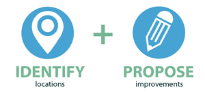
PlanLocal: Street Space is an open crowd source mapping initiative to help generate and share ideas about creating safer streets. Check out the map to see what participants suggested or double click on a location to suggest a new improvement. Press ⊕ on the map to find your current location.
Walkability
Cycling
37%
Ped-Zone
12%

 Wider sidewalks
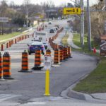 More bike lanes
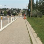 Create sidewalks
 Create pedestrian areas
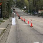
Templemead and Arno
Walkability
Currently and estimated 1/4 to 1/3 of the students at Templemead leave the schoolyard using the pathway in the pictures. In addition, a large amount of vehicular traffic travels on Templemead as a minor collector roadway. This area has parking on both sides of the street, which is also used by parents as the lot at Templemead fills up quickly at pickup and drop off times. Often it is hard to see the children coming out of the schoolyard due to parked cars, and the kids are excited to be going home often running into the intersection carefree.
We would like to see the Traffic Calming Policy enacted in this neighbourhood, bringing the speed limit to 30km/h from Arno to Golden Gate Ave, as well as 1 side of the street parking from Arno to Mount Pleasant. In addition, it is our belief that a crossing guard at this location is appropriate due to the volume of both vehicular and student traffic at this small intersection. (Please note, since the Google Maps picture attached was taken, the intersection has been updated with zebra stripe crossing lines, but they are often not being handled correctly by drivers.)
Templemead Drive School Zone
Walkability
We would like to see the Traffic Calming Policy enacted in the Templemead neighbourhood, including but not limited to:
1. An immediate reduction of speed to 30km/h along Templemead from GoldenGate Ave to Arno, and all of Royal Vista east of Upper Gage representing approximately 150m from the corners of school property;
2. A speed hump installed on Royal Vista approaching Templemead, as well as one on Templemead approaching the intersection at the front of the school.
3. Single side of the street parking in the newly signed school zone, opposite the school.
4. A crossing guard installed at Arno and Templemead (This is its own point on the map now).
And any other safety enhancements the Traffic Calming Policy would suggest.
StoneChurch and Upper Gage
walk
To avoid position jockeying at this intersection the following improvements are suggested:
1. Red Light Camera to be installed both North and South Facing. Currently there is only one on the SouthWest corner facing East.
2. Change in lane configuration for Southbound lanes, making the curbside southbound lane a right hand turn ONLY lane. This is similar in presentation to the configuration at Upper Sherman and Limeridge, Southbound.
Upper Gage at Royalvista
Walkability
To promote safety for students and other pedestrians, the following changes to this intersection are suggested:
1. To put the speed limit to 40k not 50k in a school crossing area, about half the kids that go to Templemead cross at this intersection;
2. Flashing lights during school hours;
3. Community Safety Zone signs posted;
4. Because speed in this area is so bad, we would like to suggest a speed table at this intersection;
5. School zone ahead signs posted on Upper Gage;
6. School bus stopping/ loading sign on Upper Gage where the school bus stops to pick up children;
7. And a radar speed sign reminding southbound traffic to slow down. Often these drivers have just exited the Linc and forget their in a school zone.
These suggestions should be used or considered immediately at this intersection as a response to community involvement following the tragedy that befell this neighbourhood and then a city wide amendment to the Traffic Calming Policy to allow for appropriate modifications to arterial routes should be written. The city should also be required to give an estimated timeline on rolling out the Traffic Calming Policy city wide, using the ASE funds to ensure timely protection for our most vulnerable walking commuters.
Upper Ottawa between Mohawk and Fennell
Walkability
To promote safety for students and other pedestrians, the following changes to this intersection are suggested:
1. To put the speed limit to 40k not 50k in a school crossing area, about half the kids that go to Huntington cross in this section either at Broker Dr (Controlled with a light and crossing guard) or at 10th Ave (Controlled by crossing guard only). This would be a continuation of the 40k zone that currently ends at Mohawk Road. The current configuration protects students at Highview Elementary and Sherwood High School but not at St. Margaret Mary's Elementary and Huntington Park Elementary.
2. Flashing lights during school hours;
3. Community Safety Zone signs posted;
4. And a radar speed sign reminding southbound traffic to slow down. Often these drivers have just exited the Linc and forget their in a school zone.
5. Installation of a push-button lit cross-walk at 10th Avenue.
These suggestions should be used or considered immediately at this intersection as a response to community involvement following the tragedy that befell this neighbourhood and then a city wide amendment to the Traffic Calming Policy to allow for appropriate modifications to arterial routes should be written. The city should also be required to give an estimated timeline on rolling out the Traffic Calming Policy city wide, using the ASE funds to ensure timely protection for our most vulnerable walking commuters.
Cumberland Avenue Greenway
Cycling
Walkability
Cumberland should have a barriers at Sherman preventing vehicles from cutting through from Lawrence Road to Charlton Avenue(local traffic only). Leaving more space on the road for runners cyclists and people out walking their dogs.
During the pandemic Cumberland has become a critical pedestrian and cyclist corridor. A high volume of people crowd the sidewalk and spill out onto the street in order to maintain proper distance. Family's riding bikes travel from the rail trail along Cumberland to Gage park and contend with impatient drivers that give little space when aggressively passing between Stop signs.
Why do we need another East-West cut through for car traffic? Aren't Main, King, Cannon, Wilson, Delaware, Barton, and Burlington enough?
Main Street East at Wentworth Street South
Walkability
Widen the area for passengers to wait for the bus. This can be done by taking some space from the parking lot in behind.
Ontario Avenue at Main Street
Walkability
Widen the space for passengers to wait for the bus. This can be done by taking some space from the parking lot in behind.
Erie Avenue at Main Street
Walkability
Install a pedestrian crossover so pedestrians can safely cross here rather than having to go to either Tisdale or Wentworth.
Victoria Avenue between Young and Main
Walkability
Install a pedestrian cross-over at the foot of the stairs to the rail trail. Also consider changing to two-way so that cars will actually come to a complete stop at Young and Victoria.
Crossing at Mary & Wilson
Walkability
A pedestrian crossing or full light with pedestrain crosswalk is need.
Young Street between Wellington and Victoria
Walkability
Widen the sidewalk on the north side. Consider changing to two-way traffic. Needs traffic calming - cars race to get to the stop sign at Victoria (which they then ignore).
Barton St.
Pedestrian Zone
Walkability
Make part of Barton pedestrian only for the summer months. Widen sidewalks through BIA.
Hunter bike lanes
Walkability
Best place to safely walk is on the bike lanes - Need more room for pedestrians.
Add protection to York Blvd
Cycling
Bike lane protection York Blvd to Plains Rd
Cycling
From the 403 ramps to Plains Rd there is buffer space to add concrete barrier protection to the bike lanes to create safe shared spaces. Sidewalks in this area are narrow and biking beside this heavy traffic with no protection is dangerous.
York Blvd Dundurn-403
Cycling
York Blvd Protected Spaces
Cycling
Walkability
Bike lane protection York Blvd
Cycling
Add concrete barriers to the buffer space of the York Blvd Bike lanes from Dundurn to Hess.
Parking to Pedestrian Space on Longwood
Walkability
Considering removing on street parking on Longwood's east side to convert into a pedestrian space/shared space from Marion to Franklin. Currently this street is heavily trafficked by families and the narrow sidewalks make users have to enter the street to avoid others. The northbound bikelane is disrupted by parking making it unsafe for children. This street serves as an important connection to both the Waterfront Trail and the Food Basics.
Longwood Bridge and beyond
Cycling
Walkability
Narrow Northbound traffic to 1 lane converting 1 lane to shared pedestrian/cyclist space from Frid St to Main St. Currently there is only one narrow sidewalk and I have had to step onto the busy street to get around a stroller here. Furthermore, the bike lanes do not continue over the bridge and cyclists must navigate aggressive traffic.
Emerson connection to Rail Trail
Cycling
Walkability
Remove on street parking to create protected multi-use space for cyclists/pedestrians. This is a highly trafficked street with narrow sidewalks. It also serves as an important connection to the rail trail
Connecting Cootes Dr Trail to King St through Dundas
Cycling
Walkability
Convert one eastbound lane of Cootes Dr to a protected multiuse space. This could connect Cootes Dr Trail to Dundas safely as currently users must navigate narrow sidewalks on Cootes from Dundas St to Main St and cyclists must merge with traffic. This should connect to a pedestrian/cyclist lane on King St through Dundas that could be created from removing on street parking.
Cootes Drive/Leland (connecting Cootes Trail to Rail Trail)
Cycling
Walkability
Consider narrowing Cootes Dr Southbound to 2 lanes converting 3rd lane to cyclist/pedestrian space. South of Main St, Leland could be narrowed to create a cyclist/pedestrian space on the west side of the street to connect Cootes to the Rail Trail. Currently this is a heavily trafficked area because of its many connections but sidewalks are narrow and cyclists must navigate traffic.
Remove King St Parking for cyclists/pedestrians
Cycling
Walkability
Remove Parking on (at least one side of) King st to create a protected cyclist/pedestrian space. On Cootes dr, traffic should be narrowed by one lane to connect this path to the Cootes trail
Ferguson Ave Bike Lanes
Cycling
Fully separate and add protection to these bike lanes. They could be an important access route to HHS hospitals on Barton but currently are not visibly separate from traffic.
Dundurn St King-Main
Cycling
Convert one lane of traffic to protected active transportation space using concrete curbs or barriers. Outside a Fortinos, this is a heavily traffic block with thin sidewalks. This block is also a truck route and has very poor asphalt making it extremely unsafe for cyclists connecting the Dundurn bike lanes north of King and south of Main.
King-403 onramp crossing
Cycling
Walkability
Pedestrian activated crosswalk or even yield signal for cyclists and pedestrians to safely cross onto/off of the protected King St bridge. An active transportation space is only as safe as its weakest link.
In front of family court.
Walkability
Widen sidewalk.
King St. James to Bay
Walkability
Expand side walk, convert a lane of traffic.
Cycle Lanes
Cycling
Better separation between cycle and traffic lanes.
Queen Street
Walkability
Widen side walk - too narrow. Need more space with speeding cars.
King William
Pedestrian Zone
Create pedestrian only dining area.
Cycle Lanes
Cycling
Better separation barriers between cycle and traffic lanes.
Claremont Access Underpass at Victoria Ave S & Young.
Walkability
Permanent seating area with semi-circular bench seating, child-friendly sculptures and murals, solar lights, accessibility pathing, and well-protected security devices for those who feel endangered after hours would safely repurpose this space and make it useable to the whole public.
Road Clearance at Victoria Ave S.
Walkability
West 5th St
Cycling
Extend the West 5th bike lanes north of Mohawk and connect them to the forthcoming Claremont Access bike lanes.
Wellington/Victoria
Cycling
Wellington and Victoria are both overbuilt for the volume of traffic they carry. Remove one lane on each to create north-south bike lanes.
Strathcona Ave.
Pedestrian Zone
Pedestrianize during school hours
Napier
Cycling
Alternate "safer" bike route connecting Strathcona to Downtown.
Aberdeen Ave
Cycling
Walkability
Temporarily close one lane of traffic on each side of Aberdeen Ave for Cyclists and Pedestrians. These sidewalks are heavily traffic by employees of St.Joes walking to work. At the present, there is no way to keep distance from one another.
Remove a lane of traffic on Main or King or Wilson
Walkability
Use that space to create wider sidewalks or multi use paths for East west pedestrian walking.
Main st. Intersections
Walkability
Replace failed pedestrian crossing paint. Curb cuts need to be more accessible at these crossings. Remove beg buttons for crossing.
Catherine Street
Cycling
Bike lane to ride downtown without being on crowded road
James Mountain Road
Cycling
Walkability
Dedicate lane space to help with active transportation links between mountain and downtown.
Claremont Access
Cycling
Walkability
Repurpose lane space to give more options for pedestrians and cyclists to move between upper and lower city.
Jolly Cut
Cycling
Walkability
Provide lane space to help with active transportation between the mountain and lower city employment areas.
Cannon at Lottridge
Cycling
Missing bike lanes.
Centre Mall
Walkability
Demolish and start over?
Ottawa/Maple
Walkability
Road diet for Ottawa and controlled pedestrian crossing.
Main & Catharine, NE corner
Walkability
Reduce car lanes on Main and widen sidewalks (blind corner not up to accessibility standards)
North Service Road - Grays Road to Centennial Parkway
Cycling
With the closure of Centennial Park, there are no safe bicycle connections through this stretch of North Service Road.
Aberdeen Ave.
Cycling
Walkability
Dedicate one traffic lane for pedestrians and cyclists.
Parking lots in Westdale Village
Pedestrian Zone
Close to traffic for restaurant patios.
King Street
Walkability
Reduce one lane on each side to give more width on sidewalks to pedestrians.
Main Street
Walkability
Reduce one lane on each side to give more width on sidewalks for pedestrians.
Ottawa Street (Near Cannon)
Pedestrian Zone
Walkability
Close a section of the street to traffic for the summer.
Locke (Canada to Herkimer)
Pedestrian Zone
Close to traffic for the summer.
Augusta
Pedestrian Zone
Close to traffic!
James N (Cannon to Barton)
Pedestrian Zone
Make pedestrian only
Stanley Avenue
Walkability
Allow parking on both sides of the street to slow traffic.
HAAA at Kent St.
Pedestrian Zone
Make this a pedestrian area.
Locke Street
Walkability
More space in front of Melrose United Church